- Region
- Águilas
- Alhama de Murcia
- Jumilla
- Lorca
- Los Alcázares
- Mazarrón
- San Javier
-
ALL AREAS & TOWNS
- AREAS
- SOUTH WEST
- MAR MENOR
- MURCIA CITY & CENTRAL
- NORTH & NORTH WEST
- TOWNS
- Abanilla
- Abarán
- Aguilas
- Alamillo
- Alcantarilla
- Aledo
- Alhama de Murcia
- Archena
- Balsicas
- Blanca
- Bolnuevo
- Bullas
- Cañadas del Romero
- Cabo de Palos
- Calasparra
- Camping Bolnuevo
- Campo De Ricote
- Camposol
- Canada De La Lena
- Caravaca de la Cruz
- Cartagena
- Cehegin
- Ceuti
- Cieza
- Condado de Alhama
- Corvera
- Costa Cálida
- Cuevas De Almanzora
- Cuevas de Reyllo
- El Carmoli
- El Mojon
- El Molino (Puerto Lumbreras)
- El Pareton / Cantareros
- El Raso
- El Valle Golf Resort
- Fortuna
- Fuente Alamo
- Hacienda del Alamo Golf Resort
- Hacienda Riquelme Golf Resort
- Isla Plana
- Islas Menores & Mar de Cristal
- Jumilla
- La Azohia
- La Charca
- La Manga Club
- La Manga del Mar Menor
- La Pinilla
- La Puebla
- La Torre
- La Torre Golf Resort
- La Unión
- Las Palas
- Las Ramblas
- Las Ramblas Golf
- Las Torres de Cotillas
- Leiva
- Librilla
- Lo Pagan
- Lo Santiago
- Lorca
- Lorquí
- Los Alcázares
- Los Balcones
- Los Belones
- Los Canovas
- Los Nietos
- Los Perez (Tallante)
- Los Urrutias
- Los Ventorrillos
- Mar De Cristal
- Mar Menor
- Mar Menor Golf Resort
- Mazarrón
- Mazarrón Country Club
- Molina de Segura
- Moratalla
- Mula
- Murcia City
- Murcia Property
- Pareton
- Peraleja Golf Resort
- Perin
- Pilar de la Horadada
- Pinar de Campoverde
- Pinoso
- Playa Honda
- Playa Honda / Playa Paraíso
- Pliego
- Portmán
- Pozo Estrecho
- Puerto de Mazarrón
- Puerto Lumbreras
- Puntas De Calnegre
- Region of Murcia
- Ricote
- Roda Golf Resort
- Roldan
- Roldan and Lo Ferro
- San Javier
- San Pedro del Pinatar
- Santiago de la Ribera
- Sierra Espuña
- Sucina
- Tallante
- Terrazas de la Torre Golf Resort
- Torre Pacheco
- Totana
- What's On Weekly Bulletin
- Yecla


- EDITIONS:
 Spanish News Today
 Alicante Today
 Andalucia Today
Where is La Manga del Mar Menor
La Manga lies within the administrative district of Rincón de San Ginés, Cartagena municipality
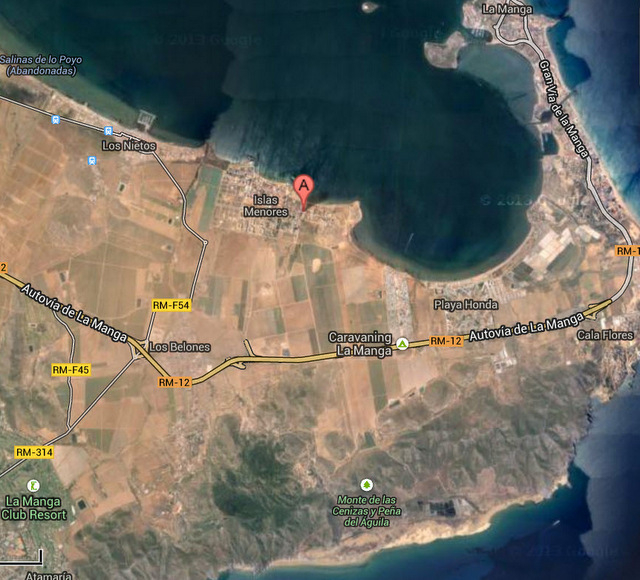
There is a great deal of confusion over the definitions of "La Manga" in this corner of the Mar Menor. The  administrative district of La Manga lies within the Cartagena municipality and is in the eastern corner of the Cartagena municipality, mainly comprising the La Manga Caravanning. Close to this is the La Manga Club, which lies slightly inland from La Manga Caravanning and Los Belones, the nearest shopping area.
This should not be confused with La Manga del Mar Menor, which lies on what is referred to by holidaymakers as "The La Manga Strip" the 20km long sandy strip of land which encloses the Mar Menor itself. Although local residents hate the term "The La Manga Strip" it is so much easier to use this term to refer to the strip of land in order to avoid confusion for hoidaymakers who frequently mix up the two distinct locations. The La Manga Strip adds further confusion for those booking holiday accommodation as it belongs to two completely differerent municipalities: the first part of the strip, which includes Cabo de Palos at "Kilometre 0" belongs to Cartagena, then part way along the strip, the administrative ownership changes to that of San Javier, so La Manga del Mar Menor actually lies within the San Javier municipality, even though the actual town of San Javier is right across on the other side of the Mar Menor.
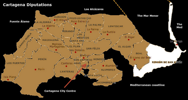
 Cartagena is a vast municipality, covering 558 square kilometres, the City of Cartagena and port at the heart of the municipality. For administrative purposes the municipality is subdivided into a series of administrative districts or diputaciones, and the main urban city into Barrios, or districts.
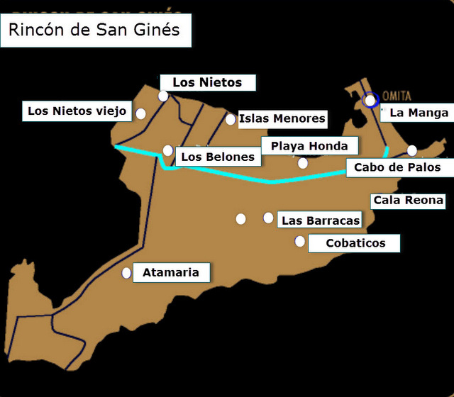
El Rincón de San Ginés is the furthest east of all the divisions within the municipality of Cartagena, and includes all the southern end of La Manga del Mar Menor (which belongs to the municipality of Cartagena), the Mediterranean coast between Cabo de Palos and Punta Negra, and the stretch of the Mar Menor coast between Los Nietos and Playa de Paraíso. It is bordered on the west by the municipality of La Unión and the El Beal diputation of Cartagena.
Cartagena has three distinct areas of coastline, the first being the enclosed area of the Mar Menor, a vast salt water lake which is non tidal and has safe, bathing beaches along its shoreline including the areas of Los Nietos, Playa Honda, Palya Paraiso, then there are 2 different areas of Mediterranean coastline.The Mar Menor is enclosed and is separated from the Mediterranean by the La Manga Strip, a 20 km long sand spit which has the Mar Menor beaches on one side and the Mediterranean on the other. Part of Cartagenas Mediterranean beaches run down this back section of the La Manga Strip and along the coast to the city. The second section run from the city along to meet the municipality of Mazarrón at Isla Plana.
 Among the towns and villages within its administrative boundaries are San Ginés, Cabo de Palos, Los Nietos, Atamaría, Las Barracas, Los Belones, Calera, Cobaticas, Corralón, Jordana, El Mojón, Los Nietos de Arriba, Cala Reona, El Sabinar, Playa Honda Islas Menores, La Manga, Mar de Cristal, Playa Paraiso and La Rivera.
This area is all just a few minutes drive from the City of Cartagena and all its amenities and locations of historical interest.
Where is La Manga Caravanning?
Click for map,La Manga Caravanning


